The Bureau of Meteorology issued a severe thunderstorm warning on Tuesday that was likely to produce intense rainfall and possible flash flooding to parts of the Mid-North Coast, Hunter, Illawarra and Central Tablelands districts, Newcastle, Gosford and Sydney.
The NSW SES recorded 623 calls for help on Tuesday and conducted 18 flood rescues, which included 45 children at a childcare centre in Tempe.

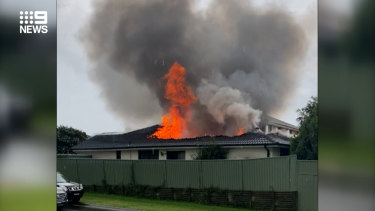
Oliver Lachat’s home was set ablaze by a suspected bolt of lightning as storms struck Sydney. Credit:Nine
There were more than 338,900 lightning pulses within a 500-kilometre radius of Tamworth between midday and midnight on Monday, which extended into Queensland and southern NSW.
Lightning may have even caused a house fire in Sydney’s west. Firefighters were called to a home in Glenmore Park just after 5.30pm on Monday and battled the blaze, which had taken hold in the roof of the property. While they contained the flames, they were unable to save the home
A City of Parramatta Council spokesperson said the heavy rainfall had resulted in some minor flash flooding in the Parramatta CBD, with water levels receding in the early evening. Three minor flood warnings for the local government areas were issued on Tuesday.
“Once the water has returned to normal levels, council will start the clean-up process,” the spokesperson said.

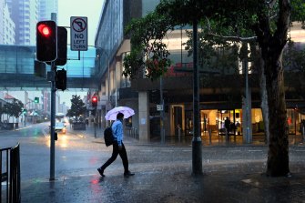
Some parts of the city recorded 76mm of rain in an hour.Credit:Kate Geraghty
The storms were expected to create further delays for afternoon commuters, who were warned that limited train services would be in place on Tuesday afternoon and possibly on Wednesday.
Trains were expected to run every 30 minutes on most lines on Tuesday afternoon and a “limited amount of buses have also been arranged”, according to Sydney Trains.
Loading
Trains stopped running in both directions between Bankstown and the city due to flooding at Marrickville station. Replacement bus services were arranged for the T3 Bankstown Line, but people were told to allow for extra travel time, Sydney Trains said.
Commuters, whether they’re driving or taking public transport, were advised to avoid any flood water.
Climate models suggest La Nina – responsible for the wetter than average summer – is near or at its peak, with a return in March to a possible neutral El Nino–Southern Oscillation status.
The climate driver known as the Southern Annular Mode index has briefly dipped to negative levels but is likely to return to positive levels into February. This could bring wetter weather to eastern parts of Australia, but drier than average conditions for western Tasmania.
Our Breaking News Alert will notify you of significant breaking news when it happens. Get it here.


 Add Category